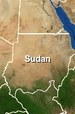
Geography & Wildlife
Flat land – mostly
Much of Sudan is flat, except for the Nuba Uplands in the centre and two main highland areas along the edges.

In the west, the Darfur Massif reaches a height of 3071 metres (the peak of Jebel Gimbala). To the east, the Red Sea Coastal Mountains rise over 2000 metres above a strip of low-lying coastal belt.
The main feature of Sudan is the Nile, which is actually two rivers in one!
Two rivers in one
Misleading names
Though it’s called the ‘Blue’ Nile, this river is more of a muddy brown. It's the waters of the ‘White’ Nile which are green-blue. The two different colours can be seen distinctly, almost as a line, where the rivers come together at Khartoum.
The waters of the White Nile travel from Lake Victoria in Uganda, which is fed by other rivers further south. But the ‘White Nile’ itself starts at Lake No in South Sudan, from where the river makes its way northwards to Khartoum.
The Blue Nile starts at Lake Tana in the highlands of Ethiopia. This river enters Sudan on its eastern border and flows to Khartoum.
Here, the two rivers meet and become one – the Nile.
Threatened wildlife
![Slender-horned gazelle, by FisherQueen (Own work) [GFDL (http://www.gnu.org/copyleft/fdl.html) or CC-BY-SA-3.0 (http://creativecommons.org/licenses/by-sa/3.0/)], via Wikimedia Commons](../sudan/images/slender-horned-gazelle-by-fisherqueen-own-work-gfdl-http-gnu.org-copyleft-fdl_html-or-cc-by-sa-3.0-http-creativecommons.org-licenses-by-sa-3.0-via-wikimedia-commons.jpg "Slender-horned gazelle, by FisherQueen (Own work) [GFDL (http://www.gnu.org/copyleft/fdl.html) or CC-BY-SA-3.0 (http://creativecommons.org/licenses/by-sa/3.0/)], via Wikimedia Commons") Large areas of Sudan’s natural plants have disappeared following hundreds of years of livestock grazing.
Large areas of Sudan’s natural plants have disappeared following hundreds of years of livestock grazing.
The country’s wildlife is also threatened by hunting. Over 20 mammal and nine bird species are endangered. Desert animals such as the Tora hartebeest, Sahara oryx and the slender-horned gazelle (Gazella leptoceros) – see photo – are now extremely rare or extinct in the wild.
One desert animal which can still be found is the African wild ass (Equus africanus). Its descendant is the donkey. The African wild ass is bluish gray/fawn and small (no more than five feet high at the shoulder). Most have a dark stripe from the mane to the tail. The Nubian ass can have a stripe across the shoulders. They live in dry areas which can't support larger mammals. Though the asses rarely come together in herds, there are strong bonds between a mother and her foals.